From Inuvik, where we spent 3 nights, we went on a trip into the MacKenzie River Delta & then by plane later to Tuktoyaktuk which I love to say, even though I do not say it as the Inuvialuit do. It's a bit of a mouthful, so many people just call it Tuk.
Photos from the river trip.....
The first surprise was that the river is used for commerce. Why hadn't I thought of that? Some shipments come north from Hay River. Tugs and barges for stuff that is huge or can be slowly hauled. We saw 1 tug pulling 3 barges.


Our pilot texted his uncle in Inuvik about it.
Later that day we did have some beluga to eat-- muktuk. I have to say I didn't like the flavor much: whale blubber, but very important for Inuit diets.


The Inuvialuit didn't like being tied down to a herd. They preferred finding animals in the wild. Some Sami from Europe's far north lived in the settlement where it was hoped they would pass on the reindeer-raising skills. The reindeer are still around & harvested at the rate of 2/day.

Below you can see the Richardson Mountains to the west.
And through this channel our pilot Kylik spotted tundra swans. He took us in to see them. They are congregating before migration.


No river trip is complete without abandoned boats, is it?
So after our lunch with mukluk & dried fish we boarded a Cessna.


...first impressions of the delta....


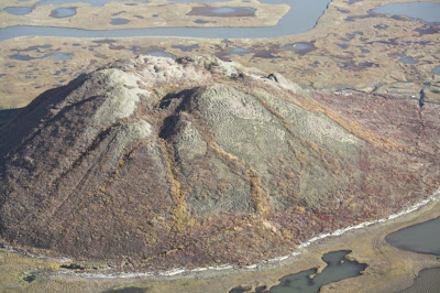
Below are 4 pictures of pingos. Pingos are made by a freezing & thawing process of old old lakes. What you are seeing is a great round frost heave. That's the best I can do.


We saw two DEW line stations: Distant Early Warning stations of the Cold War. Every 50 miles all across northern Canada. They are unmanned now and there are way fewer of them, George says.

 I wasn't expecting uneven ground like this.
 ...almost amphitheater layout... I think of Roman paving-works....

 This is the largest pingo we saw. It's right near Tuk. Notice driftwood too.
 Tuktoyaktuk from the air. Storage tanks here too.
 The Arctic Ocean meets the mighty MacKenzie River. Suddenly there are dead trees that have washed down river everywhere. It's like a forest lying on the beach.


 At the airport. This is Ian MacKenzie (no relation to the river). 90 degrees north is the North Pole. We live at 49 (point something) in Vancouver.

 This is John who gave us a two hour tour of the village.
 Another DEW point...in Tuk.
3 shots of the village. In some ways it reminded me of Newfoundland fishing villages. Maybe it's the colors & the treelessness.

 Do you notice the building on stilts? It's a solution for permafrost.

I know that if you build directly on the tundra the heat of the house will melt the permafrost & the construction will go lopsided & bent out of shape.
 A stunted cottonwood willow. Nothing grows tall here. This is the closest to a tree I saw.

Great sand pattern.


On the beach near here we all wet our hands. I tasted, but the saltiness was diluted a great deal by the river water. On the island out there is a smokehouse. And a distant pingo.

 .....two churches: below the Catholic one, newly renovated.... John would not be drawn into a discussion about the damage done by the Churches.
 We saw this characteristic sign board further south too.

A street with not too much traffic, but cars did have NWT bear license plates on them. There's a big generator in the village to power the houses, hence telephone poles.
 Digging graves here is done with serious power tools. The ground is hard, year round.


3 shots of the village. In some ways it reminded me of Newfoundland fishing villages. Maybe it's the colors & the treelessness.


Sewage is a special issue here. John talked about it, but I only understood some of it. The sewage is picked up from each dwelling every few days.

Below is the dump.

Below, the Beaufort Sea (a pocket in the Arctic Ocean) meets the MacKenzie Delta.

Going home I was on the west side of the plane. I saw a lot lakes. We flew home a different way. We got to see the Tuk-end of the extension of the Dempster Highway. Right now people can drive to Tuk on the river after freeze-up & before melt-down.
Surprisingly the new road will have very few bridges.
Since only 900 people live in Tuk it's pretty obvious the road is being put in as a step to developing gas fields here. There's a large deposit off shore.
I feel wistful about it because the MacKenzie River is Canada's longest river, its delta is unspoiled in comparison to all the other large deltas of the world. It is 'undeveloped' & pretty pristine.


What a day!!
That's it for now.
OMG Daph, what a wonderful post!! Thank you for sharing this. It is the closest I'm ever going to get to Tuk and the True North. Your narrative made me feel like I was flying alongside of you. Thank you for this!! :)
ReplyDeletemust be a luxury to have time to process all this visual, cultural and ecological info. also interesting because of recent iceland to look at the similarities. definitely going back there for a long time. also pause for thought about how life simplifies when adapting/surviving in a demanding environment looms large.
ReplyDeleteCurious. HOW did you find it?
ReplyDeleteAre you a blog-surfer?